The future of spatial data management
Gismatrix is a powerful web GIS platform combining field data collection, advanced analytics, and real-time editing. Works anywhere, even offline. Built for enterprises, designed for teams.
Features Overview
Discover the powerful features of Gismatrix that make working with spatial data easier.
Offline mode
Gismatrix works with or without a connection. Synchronization occurs automatically when a connection is available.
Izvedi večUsers and Groups
Full control over users, groups, and access rights. Subscription management in one place.
Izvedi večReporting
Generate official documents directly from the GIS interface based on your existing MS Word templates.
Izvedi večData and Layers
Advanced management of layers, visualizations, and workspaces. Support for raster and vector data.
Izvedi večImport and Export
Full interoperability. Import and export data in all industry-standard formats (CAD, GIS, Excel).
Izvedi večDrawing and Editing
A comprehensive set of tools for creating and manipulating spatial data, adapted for both office and field use.
Izvedi večWeb services and visualization
Seamless integration of external data sources (WMS, WMTS, XYZ) with unique offline capabilities and GPU acceleration.
Izvedi večAttachments and Multimedia
The system allows adding documents, images, video, and LiDAR point clouds to every object.
Izvedi večSpatial SQL Queries
Execute queries directly in the browser without an internet connection (filtering, sorting, SQL selection).
Izvedi večSpatial Functions and Analyses
Perform complex geospatial operations locally on your device, compliant with OGC standards.
Izvedi večSystem tools and security
Additional features that ensure data integrity, fast searching, and integration with street views.
Izvedi večDigitization of Your Unique Processes
Forget the limitations of standard solutions. Together, we analyze your specific workflows and develop dedicated GIS support that fits your operational needs exactly.
Izvedi večWork Anywhere, Anytime
Gismatrix does not require a constant connection. Your office is wherever you are – whether in the city center or in the most remote areas without signal.
Full Offline Mode
Download data in advance and work without limits. Edit vector layers and use raster basemaps (TPK, GeoTIFF) completely offline.
Local Spatial Analyses
Even without a server, you can perform advanced SQL queries and spatial analyses directly on the device.
Smart Synchronization
Data syncs automatically when the connection returns. Supports one-way and two-way synchronization with conflict detection.
Users, Groups, and Subscription
Security and control in one place. Manage access and monitor resource usage.
Secure Login
Support for modern authentication standards. Log in with existing Microsoft, Apple, or Google accounts (SSO) without the need for new passwords.
Roles and Permissions
Granular access control. Assign specific roles to users (e.g., Administrator, Editor, Viewer) and protect sensitive layers.
Usage Control
Transparent overview of your subscription. Monitor the number of active users, storage usage, and the status of purchased licenses in real-time.
Reporting and Document Generation
Automate bureaucracy. Generate official documents directly from the GIS interface based on your existing MS Word templates.
{content.title}
Poročilo o lokaciji
04.02.2025
1:500
Janez Novak
Smart Map Insertion
Insert a map into the document exactly where you want using a tag (e.g., {map1}). The system automatically maintains aspect ratio and current view.
Dynamic Data
Automatic population of user data, date, scale, and attributes of selected objects (e.g., {info.table}).
Script Automation
For advanced users, a JavaScript API is available for advanced logic: selection validation, executing spatial queries (Intersect), or prompting the user for additional input.
Data and Layer Management
Advanced tools for full control over your spatial data and its presentation.
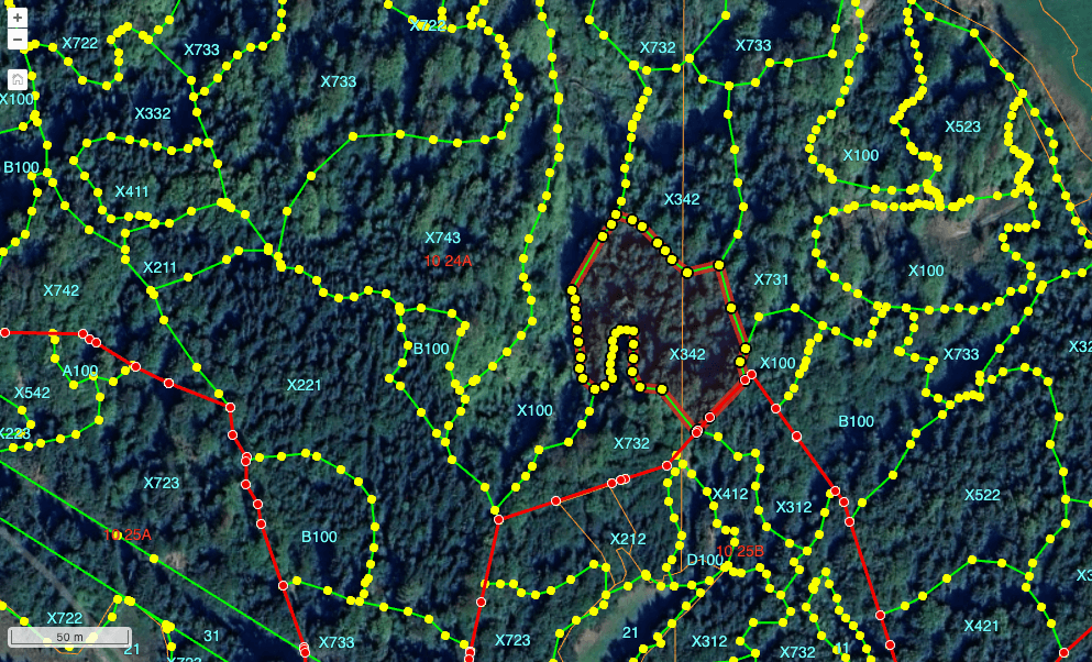
Automatic Labels
Functionality for equipping map objects with labels. The source can be an attribute column, SQL statement, or formula.
Raster Layers
Real-time adjustment of raster visualization: brightness, contrast, exposure, saturation, and gamma.
Allowed Actions
Precise definition of permissions for different types of actions on a layer, such as deleting, editing, adding, and exporting.
Time Layers
For layers with a time component, an interactive, user-adjustable time slider appears in the layer control.
State Restoration
Ability to revert the workspace to the last saved version and duplicate environments for personal customization.
Workspaces
Saving the state of the entire application (map position, active layers, styles) into dedicated "workspaces".
Thematic Layers
In addition to standard legends, legends for thematic maps and complex symbology are automatically generated and displayed.
Cosmetic Layer
Built-in "cosmetic layer" for personal annotations (visible only to the user) and a "topological layer" for geometry checking.
Legend Display
A dynamic legend is displayed for each layer, reflecting the actual state of currently visible objects on the map.
Visual Indicators
Layer control graphically displays status: layer visibility, scale dependency limits, and data loading status.
Layer Hierarchy
Support for arbitrarily changing layer order and creating layer groups (Group Layers) for easier control.
Geometry Permission
Ability to restrict geometry types in a layer (e.g., only points, lines, or polygons) or allow mixed types.
Data Import and Export
Gismatrix allows easy import and export of spatial data in various formats, ensuring interoperability with other GIS tools and platforms. Data is imported into the database and then operates fast and efficiently.
Data Export and Reporting
Complete flexibility in export. Export data to standard GIS, CAD, and Office formats, or generate advanced custom reports.
Podprti formati za izvoz
Advanced Features
Templates for Recurring Exports
Prepare export templates for fast work. Define the set of layers, attributes, and area (entire or selected) and save settings for future use.
DOCX Report Generation
Automatic creation of documents based on your Word templates. The report includes a map cutout of the current view and attribute data of selected objects.
Drawing and Advanced Editing
A comprehensive set of tools for creating and manipulating spatial data, adapted for both office and field use.
Geometry Support
Support for 2D (XY), 3D (XYZ), and 4D (XYZM) geometries. Includes profile graphs for linear objects and advanced per-row-style symbology.
Precise Drawing
Tools for snapping to vertices and edges. "Map Panning" mode (fixed target) is available for mobile devices for high precision on touch screens.
Object Manipulation
Advanced operations: splitting, merging, unmerging, and creating holes in polygons. Attribute data is automatically rewritten or merged appropriately.
Attribute Editing
Input via dynamic forms with data type validation. Support for dropdown lists populated from dynamically configurable sources (dictionaries).
Bulk Editing
Simultaneous editing of multiple selected objects. The system intelligently detects attribute differences ("Mixed" status) and allows for quick unification of values.
Smart Clipboard
Copy/Paste with automatic projection transformation between different layers. Includes full Undo/Redo support.
Cross-Updating
Automated updating of attributes on one layer based on spatial intersection with data from another layer.
Web Services and Advanced Visualization
Seamless integration of external data sources (WMS, WMTS, XYZ) with unique offline capabilities and GPU acceleration.
Standard Support
Full support for OGC standards: WMS, WMTS, COG (Cloud Optimized GeoTIFF), and XYZ sources with custom templates. Support for point clouds (LAZ/LAS).
Offline Web Sources
Unique functionality for caching data from web services to local device storage for uninterrupted field work without internet.
GPU Rendering
Hardware-accelerated raster rendering. Allows instant adjustment of brightness, contrast, saturation, and gamma directly in the interface.
Virtual Vectors
Innovative treatment of WMS layers as if they were vectors. Allows virtual selection of objects on a raster image and their further processing.
Smart Info (GetFeatureInfo)
Flexible display of object information. Support for configurable fields and structured multi-line display of query results.
Attachments and Multimedia
Enrich your spatial data. The system allows adding documents, images, video, and LiDAR point clouds to every object.
Document System
Unlimited addition of documents of any type, count, and size. All documents are securely stored and linked to the map object.
Images and Photos
Display of optimized thumbnails and viewing of high-resolution originals. Support for direct capture using the device camera in the field.
Video Integration
Built-in streaming player (MP4, WebM). Unique feature: the video timeline is displayed as a point on the line object on the map.
LiDAR Point Clouds
Direct viewing and interaction with point clouds (LAS/LAZ) in the browser without the need for additional tools. Support for basic measurements and cross-sections.
Data Security
We store all data securely in a private environment. All data is encrypted and accessible only to users with appropriate permissions.
Field Capture
Direct data capture from the field using a mobile device. Support for GPS, magnetometers, and other sensors.
Spatial SQL Queries
The data module is inextricably linked to the map. Selecting a row in the table automatically selects the object on the map and vice versa, providing immediate visual context.
-
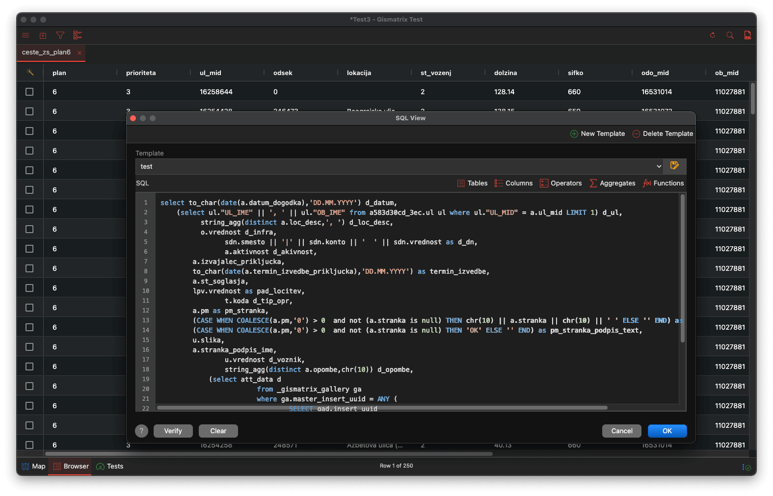
Client-side SQL: Execute queries directly in the browser without an internet connection (filtering, sorting, SQL selection).
-
Virtual Views: Create new virtual tables using complex statements (JOIN, GROUP BY, aggregate functions).
-
Direct Input: Edit attributes directly in table cells with immediate updates on the map and in thematic layers.
-
Export Results: CSV, PDF, HTML, and GIS formats for further processing.
Spatial Functions and Analyses
Izvajajte kompleksne geoprostorske operacije lokalno na vaši napravi, skladno z OGC standardi.
OGC SFS Functions
The system supports executing spatial functions within SQL expressions. These functions run locally, without the need for a server.
Selection by Location
Intuitive graphic tool for selecting objects based on spatial relationships with objects in another layer.
System Tools and Security
Additional functionalities ensuring data integrity, fast search, and connectivity with street views.
History Preservation and Traceability
We ensure complete data integrity. Every change (INSERT, UPDATE, DELETE) is recorded in archive tables.
- Preservation of existing "history tables".
- Access to all past versions of records.
- Ability to reconstruct data states.
Advanced Search Engines
Fast search by attributes or location. Results appear immediately as a selection on the map and in the table.
- Quick Search: Preset searches (parcel, address, ID).
- SQL Assistant: Graphical interface for building queries.
Topology and Validation
Automated data quality assurance. The system prevents the entry of invalid geometries.
- Validation: Repairing self-intersections and closing rings.
- Topology: Error detection (overlaps, gaps).
Street View
Full integration with street view providers (Google Street View or proprietary sources).
- Synchronization: Moving on the map refreshes the view.
- Visual Cone: Display of camera orientation.
A Living Ecosystem Tailored to You
Our platform is a living ecosystem that adapts to your processes, not the other way around. Every organization is unique, so its GIS support must be too. We don't have a 'basic module' - every solution is the result of collaboration and planned digitization of your workflows exclusively to your order.
The examples below show references and solutions we have already successfully implemented for other clients. Let them serve as inspiration for what we can build together for your organization.
Digitization of Your Unique Processes
Forget the limitations of standard solutions. Together, we analyze your specific workflows and develop dedicated GIS support that fits your operational needs exactly.
Administration and Planning
-
Centralized Data Viewer
A single entry point for the organization, allowing simultaneous viewing of all key layers.
-
Real Estate and Asset Management
Managing records of own assets, reconciliation with the state in official land registries.
-
Spatial Planning
Overview of spatial acts and automatic calculations of land use shares on individual parcels.
-
Taxation and Levies
Advanced analytics and monitoring of real estate changes as support for levy assessment.
-
Inspection Control
Support for inspectors' fieldwork with direct insight and entry of violations.
-
Public and External Stakeholders
Secure environments for public engagement, public presentation of spatial plans.
Society and Economy
-
Safe in Space
Register of safe routes to school, pedestrian crossings, and traffic signaling.
-
Tourism and Recreation
Management of data on cycling and hiking trails and tourist points.
-
Cultural Heritage
Digital cadastre of immovable cultural heritage and monuments for protection purposes.
-
Local Economy
Spatial analytics of business entities and data support for strategic decision-making.
-
Ski Resorts and Bike Parks
Management of winter-summer resorts: planning and monitoring of tracks and opening statuses.
Infrastructure and Environment
-
Public Utility Infrastructure (GJI)
Comprehensive overview of the consolidated utility cadastre, management of operational cadastres.
-
Traffic and Mobility
Management of traffic regimes, parking areas, and bike-sharing systems.
-
Road Maintenance and Winter Service
Monitoring road conditions, planning snow plowing, and supervising contractors in real-time.
-
Inspection Service
Digitization of regular road inspections and recording of damage in the field.
-
Green Area Management
Cadastre of trees and park areas, recording of arboricultural inspections.
-
Environmental Protection and Forestry
Overview of protection regimes and preparation of measures for natural heritage protection.
-
Ski Resorts and Bike Parks
Management of winter-summer resorts, track planning, and infrastructure management.
-
SCADA Data Visualization
Display of live IoT and SCADA system data on the map (flows, levels, temperatures).
-
Road Surface Condition
Digital inventory of road surface damage and visualization of wear levels.
-
Public Transport
Detailed cadastre of bus lines and stops with display of routes and schedules.
Imate specifičen izziv?
Pišite nam in skupaj bomo zasnovali GIS rešitev, ki bo optimizirala delovanje vaše organizacije.